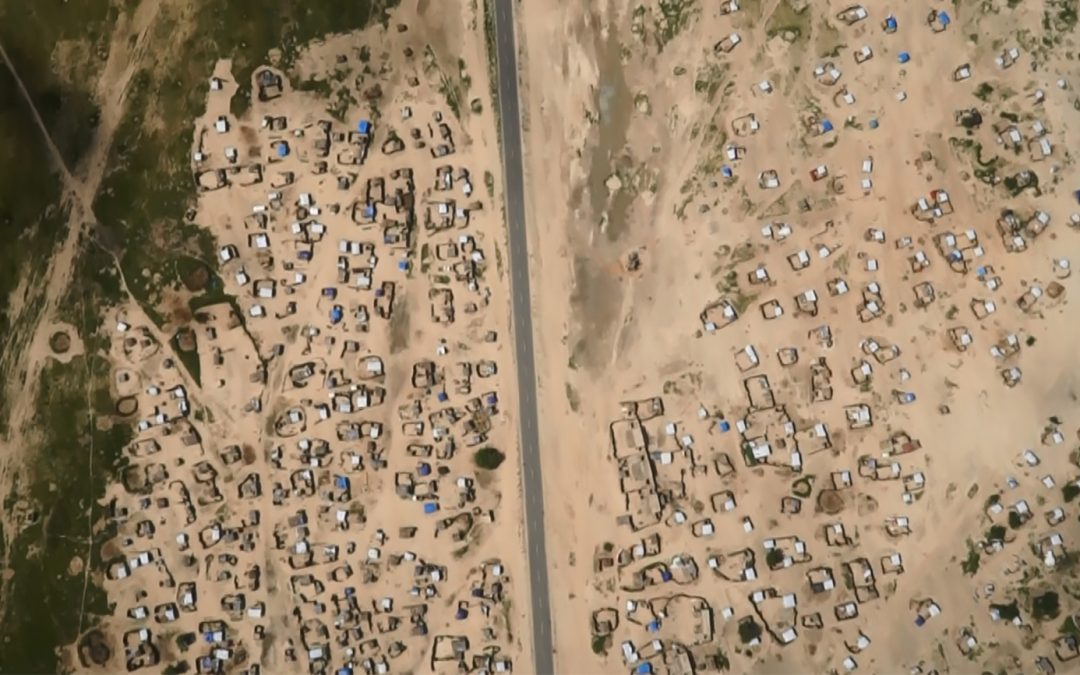
Following massive population displacements from Nigeria and within Niger in 2015 and 2016 the UNHCR operation and partners in Niger were faced with a significant mapping challenge. At the end of July 2016, there were reportedly up to 300,000 people displaced within the Diffa region, in south-eastern Niger – many scattered for kilometres in ad hoc sites. To best plan how to respond, UNHCR needs to understand which sites people have been displaced to and how many people are in each location. Enter: Aziz Kountche – a self-taught Nigerien ‘drone mapping’ expert who is working on his latest prototype: The T-800 M. This small electronic airplane flew over 75kms during my recent two-week mission to Niger – it was capturing video and still images to convert to accurate maps of the new settlements. I met Aziz carrying his flat-packed airplane on my first day in Diffa, and was fascinated to learn more.
The early drone years
Aziz’s interest in drone’s started as early as 1999 – with a 30-gram rubber band airplane – and his curiosity developed from there. He explained that the idea to move towards a remote control and then put a smartphone onboard ‘came naturally’ – the drone was born. His first version (the T-900) was made with materials sourced in Niger (plywood, glue, foam) with imported electronic components. His latest design is created from self-crafted moulds and completely assembled in Niger – elements relating to the camera design have also been designed in-country. ‘I learnt step-by-step’ said Aziz and ‘continue to learn every day’. He explains that the most challenging aspect of the design is perfecting the wings – minor imperfections significantly affect the lift and can cause crashes.
The mapping evolution
The first flight for the drone was just outside Niamey, in Kanazi, where Aziz mastered the art of remote-control flying. Following the success of these first flights, Aziz was invited to take photos of a Red Cross Luxembourg project in Gaya (Niger) and he reinvested the money earned into iterating the mapping component. This included investing in a better camera for improved resolution. Over time, and by working with GIZ, Aziz was able to invest in better software, improve his GIS mapping skills and develop partnerships to support the evolution of his project. He currently works with UNHCR, GIZ and the University of Niger amongst others.
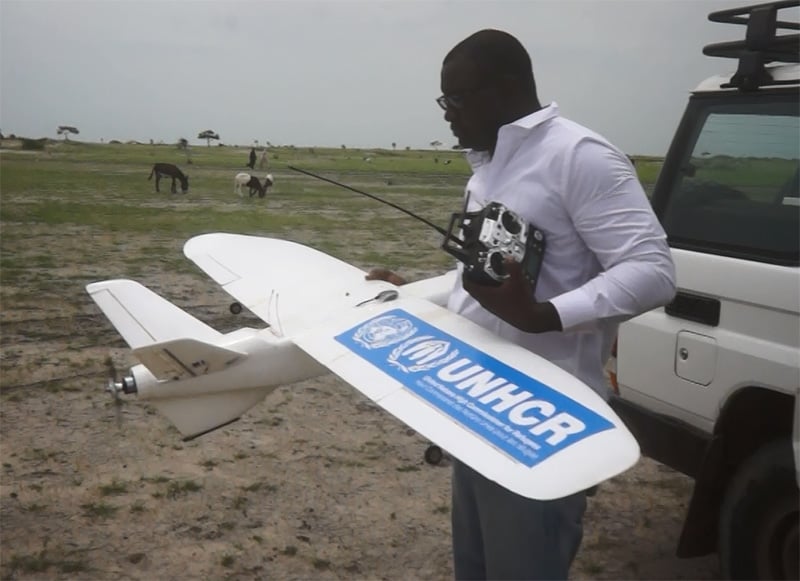
Aziz Kountche is a self-taught Nigerian ‘drone mapping’ expert currently working with UNHCR to help map displaced populations in Niger.
Working with UNHCR
Diffa is not an easy context for this project – the sensitivities of flying a drone in an area with ongoing active operations being undertaken by the Nigerien military are obvious. This was the first time that the drone had been used in an area with such security concerns. The project faced significant technical challenges, and as I left Diffa, Aziz was returning to Niamey to repair the T-800. The drone had difficulties staying on-course and was forced to land ‘off limits’ and ‘off schedule’. Although unscathed – and thankfully retrieved with support from the local community – the security risks of flying the aircraft without full control are significant. ‘After the crash, I felt so discouraged’ Aziz explains, ‘I can’t fail though, this is my passion and my job, so I need to continue step-by-step’.
Aziz has now returned to Diffa with the drone in working order and has completed the mapping of the main road area – the Route Nationale 1, where the majority of displaced people are staying in up to 100 spontaneous sites. The maps have been shared with the UNHCR operation and will be a critical resource in supporting the planning and ongoing humanitarian response across the south-east. “Since the beginning of the crisis in Diffa, the UNHCR Niger operation has provided enormous support in terms of mapping and coordination, with added expertise of the NGO partner REACH. These efforts are essential in a context where the population is scattered amongst at least 100 different sites in an area roughly the size of Belgium” stated Benoit Moreno, External Relations Officer for UNHCR Niger. The work which is ongoing with the use of the drone in Diffa will add to significantly to these efforts.
Engaging communities: where should be mapped?
Aziz and I discussed how communities themselves could be engaged in the project, supporting both the mapping activities and the ongoing iteration of the project itself. Currently, the team needs to visit each mapped location twice – once to collect GPS coordinates for charting the route and a second time for the imaging itself. Aziz is keen to see how communities can be engaged to recommend areas for mapping, support with scoping and share GPS coordinates – this would make the process both more efficient and more community-led.
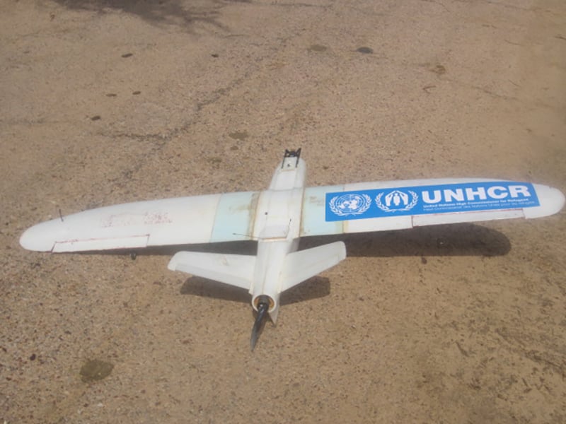
Aziz Kountche’s latest prototype: the T-800. The drone will help support UNHCR’s planning and ongoing humanitarian response in Diffa, Niger.
Where next?
There are plans to expand the drone mapping project beyond Niger. Aziz is also thinking of ways to continue iterating the design – and is exploring possibilities to develop a special drone and ‘integrated application’ that can be directly used by UN agencies and partners. This would allow teams to access mapping information, real-time, through their own smartphone or tablets.
The use of the drone will strengthen the mapping work already being undertaken by UNHCR in Niger. As noted by Benoit Moreno, “With the use of the drone images, we want to provide a new level of mapping to strengthen our analysis of the context. With these images, we can do many things, for example, observe the evolution of the sites, cross check the information and the data regarding the registration figures, count the number of shelters present, and observe the presence of trees in areas where gas has been distributed as domestic energy, amongst others”.
We’re always looking for great stories, ideas, and opinions on innovations that are led by or create impact for refugees. If you have one to share with us send us an email at [email protected]
If you’d like to repost this article on your website, please see our reposting policy.